pixel

Placemaker Subscription

$399.00 NZD +GST / year

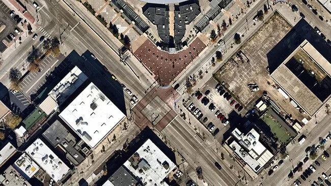
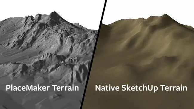
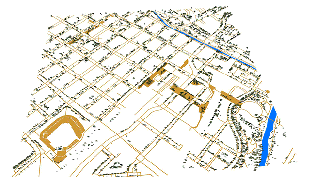
Placemaker is an extension for SketchUp that allows you to bring in high resolution map data and create cities in a single click. It brings in geographical data and creates streets, paths, buildings, bodies of water, and more. Includes 1000x Credits.

100% NZ owned and operated – Buy from us for local support.

SKU: SU-PLUGIN-PLACEMAKER Category: Brand:

Description

PlaceMaker v3

The PlaceMaker plugin for SketchUp allows you to import high resolution Aerials, 3D buildings, Parametric 3D roads and walks and even bodies of water and trees – everything to get your project started with rich context and detail. You have access to global data of cities and towns. It will save you hours, if not days of work creating city model replicas. Easy to learn and simple to use, just geolocate your site and start importing. 

High Resolution Aerials

One of PlaceMaker’s most popular features are the High resolution aerials from Mapbox and Nearmap. Get unprecedented imagery quality for many locations around the world. Mapbox provides global coverage, with sharp imagery for most major world cities. Nearmap’s almost 3.5cm resolution and recency is a game changer for modeling and presentation.

high res aerial images
sketchup placemaker terrain comparison

High Quality Terrain

PlaceMaker now offers access to high quality terrain from Cesium. The high quality terrain adds a new level of accuracy and granularity to terrain models. Terrain resolution varies by location. The coverage is global and the results detailed.

You can even drape aerials, 3D buildings, roads and other infrastructure onto the terrain surfaces.

3D Cities & Infrastructure

40 hours of work in 4 minutes! Quick, full of detail and easy to use, the popular PlaceMaker Extension for SketchUp lets you import 3D building massings, road and walk surfaces, high resolution aerials, trees, water and more.

It’s global data for cities and towns AROUND the WORLD.

placemaker city models
sketchup placemaker terrain comparison

AI Generated Surveys

Digitizing the world with Artificial Intelligence. PlaceMaker is happy to bring you SmartSite; top of the class, next generation vector data. Using AI, SmartSite takes high-resolution aerials and transforms them into accurate site plans that include roads, walks, paths, sports fields, parking areas, bridges, highways, lawns, open spaces and much more.

Available in SketchUp and DWG (CAD) formats. Does not require the purchase of the PlaceMaker Plugin.

Instant City Builder

Stop wasting your project budget on creating site context. PlaceMaker automates the creation of your site model with one click!

• Import High resolution aerial imagery from Google 3D Map Tiles
• Imports roads, walks, paths, water and 3D building massing models
• Imagery, roads, paths, water and buildings can be imported directly onto terrain.